Feb 18th Border Wall-k Recap
For lots more Pics of the day, go to http://share.shutterfly.com/action/welcome?sid=0IcuGTJm3YsX2g

The day started out bright and early with Jay Johnson Castro, Sarah, Michelle, and I driving to the starting point in Otay by 7:20am. Jeffrey met us there. Jay, Jeffrey, and I started the Wall-k at about 7:45am. Jay started right away with stories of activism and tearing down walls of secrecy and abuse of the US gov't. From what we had seen on the Google satellite and what Border officials had warned us about, we thought this first portion of the trip was going to be a difficult hike and would take at least 4 hours. Instead, it turned out to be less than two hours with only some slow slopping hills on a groomed gravel road. We saw quite a few cottontails and a couple Burrowing Owls along the trek to San Ysidro port of entry. It felt a little like we were all just starting to get to know each other (J, Jeff, and I) when, all of the sudden, we saw the end of the trail. "Is that it…? Is that the San Ysidro port of entry already...? Nah, couldn't be." But, sure enough, about 1.5 hours into the wall-k we were only 20 minutes away. Michelle and Sarah, along with some attractive young film students, greeted us as we arrived there. We met Sarah and Michelle at the Plaza de Las Americas shopping center about 15 min down the road (wall-king) and sat and chatted and ate our snacks and water for about an hour.
We then continued on for another 2-3 miles along city streets to the meeting spot behind the water treatment plant on Dairy Mart Rd. and met with about 20 others. I got quite a few compliments and looks about my sign “Make Friends Not Fences/ Amigos sin front eras” on the way there. There were some media cameras at the meeting spot, Diego and Eileen, Richard and Aida, Paul, Enrique, Danni Morales, Vicente and others from the Marcha Migrante showed up.

We wall-ked right into the area of construction but were blocked off by a National Guard officer in a pickup truck. He wouldn't talk to us and just kept signaling that we go back. I recognized him from the last trip out and finally got him to talk a bit. I told him that we had forewarned BP and other officials of our plans, but he wasn't hearing it. He would not let us go through the area where the construction was happening, no matter what. We had Richard, a native to the area and an archeologist / paleontologist by profession. With his knowledge of the region and a little bit of guess work we started to skirt around the construction areas to find our way over the Mesa and down into Smuggler's Gulch. As we came up kind of a tough climb (a bit treacherous at times) up the Mesa there were two National Guard and two Border Patrol agents waiting for us. All dressed in full combat gear. The construction was right behind them. The National Guard was video taping us as we wall-ked up. "Do you know the best way to go down into Smuggler's Gulch while staying a safe distance from the construction?" I asked the National Guard guy with a camera in his hand. He didn't answer and just signaled me to wall-k away while still filming. We stopped there, I think kind of half expecting to get arrested or talked to or something, but the Guard and BP just stood there and looked at us. The BP talked back some when we greeted them and one, in Spanish, obviously Mexican. It was the first time I'd seen BP with bulletproof vests and helmets on. I guess we were pretty intimidating :-) with our make friends signs and peace flags. We continued to meander through the trails and every time we got close to the construction area, there was a truck with the same officer, putting down cones to make sure we didn't go into the area. Some in the group wanted to challenge him, but I didn't think it was worth it. Despite the construction being somewhat of a covert operation, I honestly think this particular officer was afraid someone would get hurt and was afraid he’d get in trouble or if we did. But then again, I don't really know what the complete motives were for sure for not letting us in.
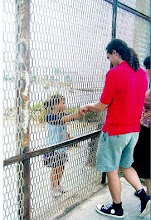
Once we got around the construction, we went back against the fence and there were some people on the other side, just hanging out. We went up and tall-ked to them through the small holes in the fence. They all had different but similar stories. Most had been to this side before and were working and then got deported and are now trying to get back. Some, like the 63 year Jacinto, had left family in the US. Jacinto was trying to get back to his wife and 4 daughters in Michigan. We chatted with him more than anyone else. He was hungry and thirsty, so we gave him some snacks and agua. I’ve heard several stories like this in the past. It’s just not right. People are people and no one should have more or less of a right to work and see their family. We then continued on. Jay had already gone ahead to meet up with the media folks whom we had lost due to the extra climbing . Finally, we made it into Smuggler’s Gulch, where we were able to meet and talk with more amigos through the fence. The steep Mesas to the west were a bit intimidating, but I didn't think about it much "Vámonos amigos." As we climbed and descended two very steep Mesas, the same gentleman, Richard, who helped find the alternative trail to go around the construction earlier, was fascinating to wall-k with. He explained that some of the Quartz rocks were a billion years old! He also pointed out some rocks that had been made into tools. He said, this area where we found these rocks/tools, was an archeological site that will be ruined by the construction/filling in of the canyons. He also pointed out a WW1 bunker on the second to last Mesa before the park. Because he had so much experience on the trails, he was also able to point out things like a knitted shoe sock, that was used to hide tracks as people wall-ked in hopes of not getting caught by border patrol trackers as well as explaining that whenever we saw a comb (which we saw quite a few of) that was a spot where someone was caught and was asked to take anything sharp out of their pockets. Our support crew met up with us one more time about a mile from the beach.
 One of the Wall-kers opted for the ride but the rest of us made it the last mile. Along the way we met up with some more amigos through the fence and one who lived in a drainage pipe that goes under the wall. Jeffrey traded his Marcha Migrante shirt for the black shirt that the amigo had on. Jeffrey's cool.

When we finally got to the beach there was quite a reception. Some congress people were being given a tour of the border by BP and DHS. There were 40-50 BP officials and police wandering around talking, 3-4 helicopters overhead, and two Border Patrol Boats in the ocean. It was quite a site. Three of the congress people came to the fence to talk to people through the fence. I was happy about that. I felt like they were kind of having a dignitary party about 30 feet from the fence while Mexicans looked on. When we got there, we kind of broke up their exclusive party and managed to get a few of them over to the fence. A congresswoman, I think from Michigan, came to the fence and asked what it is that Mexicans want her to do to help. One guy told her to arrest the minutemen and let us go to work and tell border patrol to stop turning the other cheek when minutemen beat us up. I asked Filner what he thought of the construction and he said “It’s a disgrace.”
Finally, I talked with my friend José who lives and works in the bathroom at the In_Site garden on the Tijuana side. We chatted for a while and I introduced him to some of my friends. He’s responsible for keeping the area up. He calls it his garden.
For more Pics, go to http://share.shutterfly.com/action/welcome?sid=0IcuGTJm3YsX2g
For lots more Pics of the day, go to http://share.shutterfly.com/action/welcome?sid=0IcuGTJm3YsX2g

The day started out bright and early with Jay Johnson Castro, Sarah, Michelle, and I driving to the starting point in Otay by 7:20am. Jeffrey met us there. Jay, Jeffrey, and I started the Wall-k at about 7:45am. Jay started right away with stories of activism and tearing down walls of secrecy and abuse of the US gov't. From what we had seen on the Google satellite and what Border officials had warned us about, we thought this first portion of the trip was going to be a difficult hike and would take at least 4 hours. Instead, it turned out to be less than two hours with only some slow slopping hills on a groomed gravel road. We saw quite a few cottontails and a couple Burrowing Owls along the trek to San Ysidro port of entry. It felt a little like we were all just starting to get to know each other (J, Jeff, and I) when, all of the sudden, we saw the end of the trail. "Is that it…? Is that the San Ysidro port of entry already...? Nah, couldn't be." But, sure enough, about 1.5 hours into the wall-k we were only 20 minutes away. Michelle and Sarah, along with some attractive young film students, greeted us as we arrived there. We met Sarah and Michelle at the Plaza de Las Americas shopping center about 15 min down the road (wall-king) and sat and chatted and ate our snacks and water for about an hour.
We then continued on for another 2-3 miles along city streets to the meeting spot behind the water treatment plant on Dairy Mart Rd. and met with about 20 others. I got quite a few compliments and looks about my sign “Make Friends Not Fences/ Amigos sin front eras” on the way there. There were some media cameras at the meeting spot, Diego and Eileen, Richard and Aida, Paul, Enrique, Danni Morales, Vicente and others from the Marcha Migrante showed up.

We wall-ked right into the area of construction but were blocked off by a National Guard officer in a pickup truck. He wouldn't talk to us and just kept signaling that we go back. I recognized him from the last trip out and finally got him to talk a bit. I told him that we had forewarned BP and other officials of our plans, but he wasn't hearing it. He would not let us go through the area where the construction was happening, no matter what. We had Richard, a native to the area and an archeologist / paleontologist by profession. With his knowledge of the region and a little bit of guess work we started to skirt around the construction areas to find our way over the Mesa and down into Smuggler's Gulch. As we came up kind of a tough climb (a bit treacherous at times) up the Mesa there were two National Guard and two Border Patrol agents waiting for us. All dressed in full combat gear. The construction was right behind them.
 The National Guard was video taping us as we wall-ked up. "Do you know the best way to go down into Smuggler's Gulch while staying a safe distance from the construction?" I asked the National Guard guy with a camera in his hand. He didn't answer and just signaled me to wall-k away while still filming. We stopped there, I think kind of half expecting to get arrested or talked to or something, but the Guard and BP just stood there and looked at us. The BP talked back some when we greeted them and one, in Spanish, obviously Mexican. It was the first time I'd seen BP with bulletproof vests and helmets on. I guess we were pretty intimidating :-) with our make friends signs and peace flags. We continued to meander through the trails and every time we got close to the construction area, there was a truck with the same officer, putting down cones to make sure we didn't go into the area. Some in the group wanted to challenge him, but I didn't think it was worth it. Despite the construction being somewhat of a covert operation, I honestly think this particular officer was afraid someone would get hurt and was afraid he’d get in trouble or if we did. But then again, I don't really know what the complete motives were for sure for not letting us in.
Once we got around the construction, we went back against the fence and there were some people on the other side, just hanging out. We went up and tall-ked to them through the small holes in the fence. They all had different but similar stories. Most had been to this side before and were working and then got deported and are now trying to get back. Some, like the 63 year Jacinto, had left family in the US. Jacinto was trying to get back to his wife and 4 daughters in Michigan. We chatted with him more than anyone else. He was hungry and thirsty, so we gave him some snacks and agua. I’ve heard several stories like this in the past. It’s just not right. People are people and no one should have more or less of a right to work and see their family. We then continued on. Jay had already gone ahead to meet up with the media folks whom we had lost due to the extra climbing . Finally, we made it into Smuggler’s Gulch, where we were able to meet and talk with more amigos through the fence. The steep Mesas to the west were a bit intimidating, but I didn't think about it much "Vámonos amigos." As we climbed and descended two very steep Mesas, the same gentleman, Richard, who helped find the alternative trail to go around the construction earlier, was fascinating to wall-k with. He explained that some of the Quartz rocks were a billion years old! He also pointed out some rocks that had been made into tools. He said, this area where we found these rocks/tools, was an archeological site that will be ruined by the construction/filling in of the canyons. He also pointed out a WW1 bunker on the second to last Mesa before the park. Because he had so much experience on the trails, he was also able to point out things like a knitted shoe sock, that was used to hide tracks as people wall-ked in hopes of not getting caught by border patrol trackers as well as explaining that whenever we saw a comb (which we saw quite a few of) that was a spot where someone was caught and was asked to take anything sharp out of their pockets. Our support crew met up with us one more time about a mile from the beach.
 One of the Wall-kers opted for the ride but the rest of us made it the last mile. Along the way we met up with some more amigos through the fence and one who lived in a drainage pipe that goes under the wall. Jeffrey traded his Marcha Migrante shirt for the black shirt that the amigo had on. Jeffrey's cool.
When we finally got to the beach there was quite a reception. Some congress people were being given a tour of the border by BP and DHS. There were 40-50 BP officials and police wandering around talking, 3-4 helicopters overhead, and two Border Patrol Boats in the ocean. It was quite a site. Three of the congress people came to the fence to talk to people through the fence. I was happy about that. I felt like they were kind of having a dignitary party about 30 feet from the fence while Mexicans looked on. When we got there, we kind of broke up their exclusive party and managed to get a few of them over to the fence. A congresswoman, I think from Michigan, came to the fence and asked what it is that Mexicans want her to do to help. One guy told her to arrest the minutemen and let us go to work and tell border patrol to stop turning the other cheek when minutemen beat us up. I asked Filner what he thought of the construction and he said “It’s a disgrace.”
Finally, I talked with my friend José who lives and works in the bathroom at the In_Site garden on the Tijuana side. We chatted for a while and I introduced him to some of my friends. He’s responsible for keeping the area up. He calls it his garden.
For more Pics, go to http://share.shutterfly.com/action/welcome?sid=0IcuGTJm3YsX2g
posted by Daniel at 3:19 PM
3 comments
![]()
![]()